
Machine learning and AHP as tools for identifying critical points for fires

Forests are an important component of both resources and the environment. As the most widely distributed ecosystem on Earth, forest ecosystems are characterized by abundant species, complex structures, and diverse resources. The powerful carbon sequestration ability of forests plays a crucial role in maintaining ecological balance and significantly impacts climate change.
Globally, raging forest fires affect biodiversity, wildlife habitat, and ecosystem attributes. About 84 % of the world's ecoregions are threatened by forest fires, severely affecting biodiversity. Forests, which play an important role in carbon sinks, may become a source of carbon to the atmosphere even after forest fires due to the death of trees in fire-affected areas.
According to the Fifth Assessment Report of the Intergovernmental Panel on Climate Change (IPCC), annual carbon emissions from forest fires range from 2.5 to 4 billion tons of carbon dioxide. Forest burning degrades air quality due to the emission of large amounts of particulate matter and trace gases. Land degradation due to forest fires is also a common problem. As a result of forest fires, large amounts of ash, carbon, and toxic substances are produced and contaminate the air, water, and soil, and the contaminated air, water, and soil affect soil nutrients and microorganisms, altering the productivity of the soil.
Fire prevention is an essential tool and an important public policy to help reduce greenhouse gases. According to the National Interagency Fire Center, the 10-year average cost of fire suppression in the US is estimated to be $2,358,603,800. In this context, a Fire Hazard Map can help the agents involved in the process of fighting forest fires to reduce the occurrence of fires at a much lower cost. Fire hazard management begins with an assessment of the most flammable locations and the measures needed to limit their impact, especially when forest fire hazard (FFH) is available.
We present a methodology that combines machine learning with variables associated with ignition, dispersion, and combustible material for FFH assessment that produces thematic maps with a high spatial resolution (10 m), allowing us to identify critical locations down to the property level - and hotspots for fire occurrence. In the context of climate change, deforestation, and fires in the Amazon basin, we tested and developed our methodology in the states of Amazonas/Brazil, Portugal, and El Dorado County in California.
Materials and methods
This research was divided into three separate areas:
1) Humaitá: a municipality in the Brazilian state of Amazonas;
2) El Dorado: a county in California, USA, which includes the Eldorado National Forest; and
3) Belmonte: a city in Portugal's Serra da Estrela region.
The suggested methodology was built on previous research and assessed 12 factors (fixed and dynamic), using machine learning techniques and the Analytic Hierarchy Process (AHP) to determine their weights in the FFH calculation using a novel approach. The predictive values enable the FFH to be predicted for up to 10 days by daily updating some factors (nanosatellite data). Figure 1 shows the data processing flowchart used to calculate the FFH and display it on the Flareless platform.


Figura 1: Workflow processing
Discussion
The thematic maps (FFH) for the three locations that took the dates into account are shown in Figure 2:
a) Humaitá: from July 29 to August 28, 2021;
b) El Dorado: from August 12 to September 25, 2021; and
c) Belmonte: from July 1 to July 31, 2022.

Figure 2: Forest Fire Hazard for a) Belmonte, b) Humaitá e c) El Dorado.
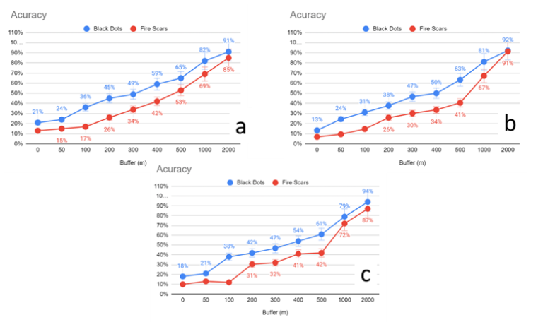
Data were compared with the fire scars found for the days just after the calculation to confirm the accuracy of the maps. The most illustrative instance was El Dorado, where a high hazard point (black dot) was identified up to 45 days in advance and later developed into a Caldor Fire. The outcome of this crossover is depicted in Figure 3.
Conclusions:
By comparing high- and extremely high-hazard areas with fire scars, the established methodology showed an accuracy of around 80%. The accuracy in identifying areas with a high or very-high fire hazard is enhanced with the use of precise meteorological data. Forthcoming, research will focus on determining Above Ground Carbon (AGC), improving the prediction of hazard fires, and providing information on the amount of AGC preserved.
References:
Parisien, M.A.; Miller, C.; Parks, S.A.; DeLancey, E.R.; Robinne, F.-N.; Flannigan, M.D. The spatially varying influence of human on fire probability in North America. Environ. Res. Lett. 2016, 11, 075005.
Tariq, A.; Shu, H.; Li, Q.; Altan, O.; Khan, M.R.; Baqa, M.F.; Lu, L. Quantitative Analysis of Forest Fires in Southeastern Australia Using SAR Data. Remote Sens. 2021, 13, 2386.
Dr. Marcos Benedito Schimalski
MSc. Bill Herbert
Eng. Florestal Roni Pavarin
* Dr. Marcos Benedito Schimalski is a Cartographic Engineer, PhD in Geodetic Sciences and Research Director at Quiron; MSc. Bill Herbert is a Forest Engineer, Master in Forest Engineering, Researcher at Quiron; Roni Pavarin is a Forest Engineer and Researcher at Quiron.